Transform Your Projects with Geotrix
Visualise Your Data
Enhance your operations with Geotrix's advanced data mapping solutions.


TRANSFORM YOUR PROJECTS WITH
GEOTRIX
Visualise Your Data
Enhance your operations with Geotrix's advanced data mapping solutions
Offerings
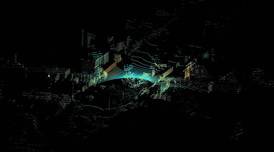
Our expertise empowers you to leverage cutting-edge technology, including Lidar and GPS, for capturing precise digital data and creating breathtaking 3D virtual tours. Unlock actionable insights with our comprehensive digital asset management and corridor mapping services, tailored to meet your specific needs. Experience improved workflows and bring your vision to life through aerial capture and photogrammetry. Discover the unmatched accuracy and detail we provide for your projects.

Transform your spatial data into actionable insights with Geotrix innovative data mapping capabilities.
Tailored Solutions
We provide tailored Data Mapping Solutions that are designed to meet the unique needs of each of our clients.
Corridor Mapping
Corridor mapping "close capture" is a process of creating detailed digital representations of linear infrastructure such as roads, power lines, pipelines, and railways. It involves using technologies like aerial photography, LiDAR, and high-precision geo-referencing to capture spatial data and create comprehensive maps.

3D Virtual Tours
3D virtual tours, also known as digital twins, are interactive, immersive online experiences that allow users to explore a space as if they were physically there. These tours utilise specialised cameras and software to capture a space in 3D, creating a navigable environment that can be accessed on various devices.
Client projects
Our clients benefit from the tailored solutions we provide
We provide our services to one of Auckland's leading structural engineering firms, mapping utilities by way of close capture corridor mapping.
Our 3D virtual tour has enhanced the telecoms industry, offering an immersive exploration of the exchange environments as if they were physical there, with an accurate view of identifiable assets offering measurement capabilities.
The property industry benefits from 3D Virtual Tours giving prospective home buyers the experience of walking through a dwelling before scheduling a physical visit.
Advantages
Transform your understanding of spatial environments with Geotrix's innovative data mapping capabilities
Enhance Your Vision, Unleash Innovation
Maximize Accuracy
At Geotrix, we recognized the need for separating the labor-intensive task of capturing data, allowing businesses to focus on their core services and products to their clients. Discover how we can help you make informed decisions with our reliable services.
Tailored Data Mapping Solutions
Our expertise in 3D virtual tours and corridor mapping empowers you to visualize complex environments with precision, ensuring optimal project outcomes.
Comprehensive Digital Asset Management
Explore our services that streamline your workflow, making it easy to access and utilise essential data for better decision-making.
3D Technology
These tours utilise specialised cameras and software to capture a space in 3D, creating a navigable environment that can be accessed on various devices. They are commonly used in real estate, business marketing, and education to showcase properties, facilities, and products.